


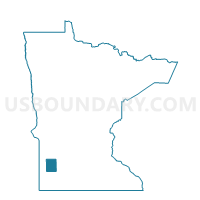
Westerheim Twp. Voting District, Lyon County, Minnesota
About
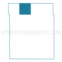
Outline

Summary
| Unique Area Identifier | 602965 |
| Name | Westerheim Twp. Voting District |
| County | Lyon County |
| State | Minnesota |
| Area (square miles) | 36.26 |
| Land Area (square miles) | 36.26 |
| Water Area (square miles) | 0.01 |
| % of Land Area | 99.98 |
| % of Water Area | 0.02 |
| Latitude of the Internal Point | 44.59319320 |
| Longtitude of the Internal Point | -95.91964090 |
Maps

Graphs
Select a template below for downloading or customizing gragh for Westerheim Twp. Voting District, Lyon County, Minnesota


Neighbors
Neighoring Voting District (by Name) Neighboring Voting District on the Map
- Burton Twp. Voting District, Yellow Medicine County, MN
- Eidsvold Twp. Voting District, Lyon County, MN
- Grandview Twp. Voting District, Lyon County, MN
- Minneota Voting District, Lyon County, MN
- Nordland Twp. Voting District, Lyon County, MN
- Normania Twp. Voting District, Yellow Medicine County, MN
- Swede Prairie Twp. Voting District, Yellow Medicine County, MN
- Vallers Twp. Voting District, Lyon County, MN
Top 10 Neighboring County Subdivision (by Population) Neighboring County Subdivision on the Map
- Minneota city, Lyon County, MN (1,392)
- Grandview township, Lyon County, MN (288)
- Eidsvold township, Lyon County, MN (236)
- Westerheim township, Lyon County, MN (235)
- Vallers township, Lyon County, MN (214)
- Nordland township, Lyon County, MN (213)
- Normania township, Yellow Medicine County, MN (191)
- Swede Prairie township, Yellow Medicine County, MN (170)
- Burton township, Yellow Medicine County, MN (148)
Top 10 Neighboring Place (by Population) Neighboring Place on the Map
Top 10 Neighboring Unified School District (by Population) Neighboring Unified School District on the Map
- Marshall Public School District, MN (15,742)
- Yellow Medicine East School District, MN (7,006)
- Lakeview School District, MN (2,735)
- Minneota Public School District, MN (2,589)
Top 10 Neighboring State Legislative District Lower Chamber (by Population) Neighboring State Legislative District Lower Chamber on the Map
Top 10 Neighboring State Legislative District Upper Chamber (by Population) Neighboring State Legislative District Upper Chamber on the Map
Top 10 Neighboring 111th Congressional District (by Population) Neighboring 111th Congressional District on the Map
Top 10 Neighboring Census Tract (by Population) Neighboring Census Tract on the Map
- Census Tract 3601, Lyon County, MN (3,726)
- Census Tract 3602, Lyon County, MN (3,307)
- Census Tract 9703, Yellow Medicine County, MN (2,517)